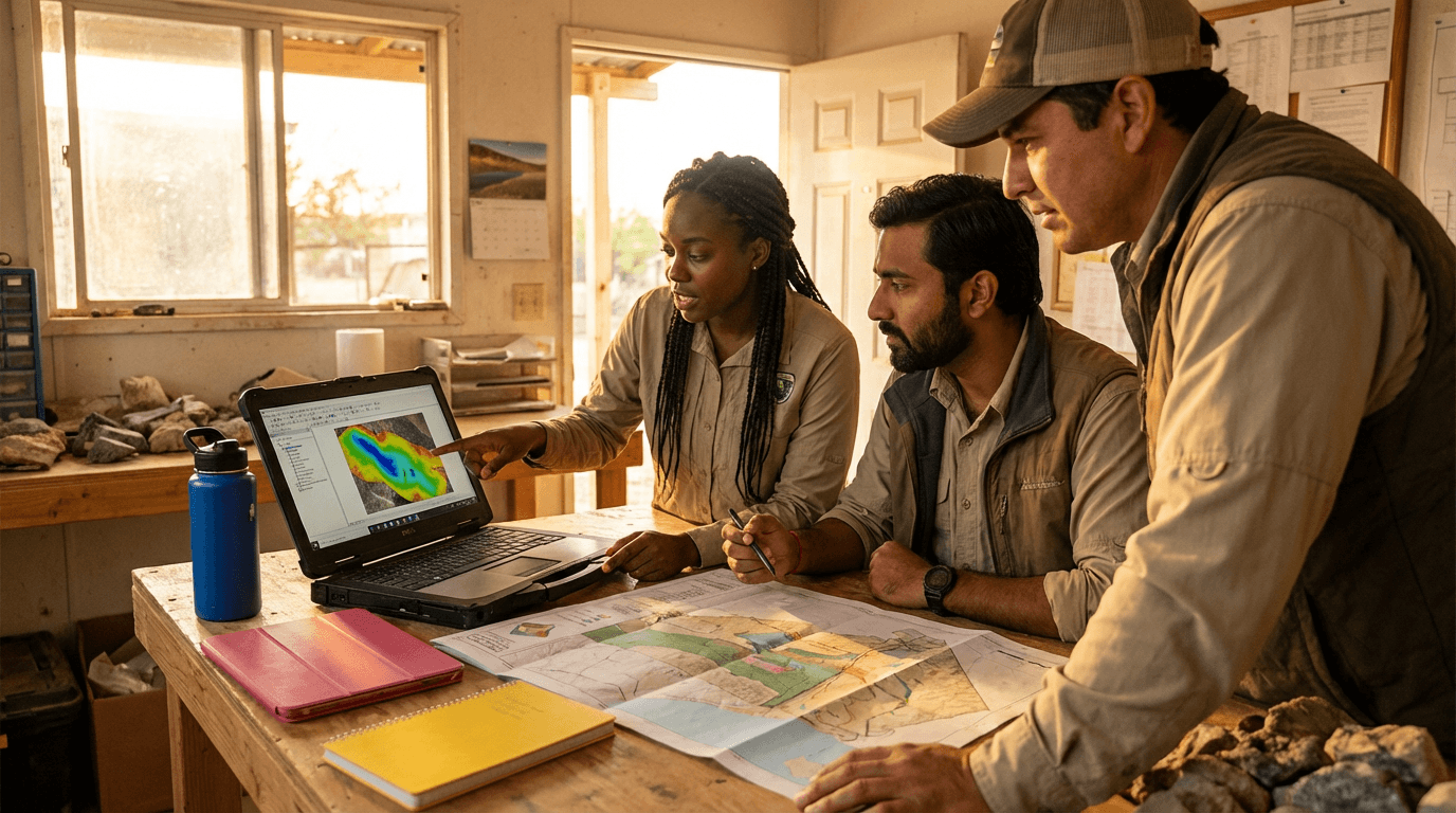
ਹਾਈਡ੍ਰੋਜੀਓਲੌਜੀ ਵਿੱਚ ਲਾਗੂ ਕੀਤੀਆਂ ਜੀਆਈਐੱਸ ਤਕਨੀਕਾਂ ਦਾ ਕੋਰਸ
ਹਾਈਡ੍ਰੋਜੀਓਲੌਜੀ ਲਈ ਜੀਆਈਐੱਸ ਤਕਨੀਕਾਂ ਵਿੱਚ ਮਾਹਰ ਬਣੋ ਅਤੇ ਕੁੱਦੇ ਸਪੇਸ਼ਲ ਡੇਟੇ ਨੂੰ ਸਾਫ਼ ਭੂਅੰਡਰ ਵਾਟਰ ਸੰਭਾਵਨਾ ਅਤੇ ਜੋਖਮ ਨਕਸ਼ਿਆਂ ਵਿੱਚ ਬਦਲੋ। ਭੂਗੋਲ ਅਤੇ ਭੂਵਿਗਿਆਨ ਪੇਸ਼ੇਵਰਾਂ ਲਈ ਆਦਰਸ਼ ਜੋ ਐਕੁਇਫਰ ਨਕਸ਼ੇਬੰਦੀ, ਵਰਤੋਂ ਦੀ ਅਸਮੱਲਾਨ ਅੰਦਾਜ਼ਾ ਅਤੇ ਨਿਗਰਾਨੀ ਫੈਸਲਿਆਂ ਲਈ ਵਿਹਾਰਕ ਵਰਕਫਲੋ ਚਾਹੁੰਦੇ ਹਨ।
4 توں 360 گھنٹے تک لچکدار ورک لوڈ
تہاڈے ملک وچ قابل قبول سرٹیفکیٹ
میں کی سکھاں گا؟
ਇਹ ਛੋਟਾ ਵਿਹਾਰਕ ਕੋਰਸ ਤੁਹਾਨੂੰ ਦੱਸਦਾ ਹੈ ਕਿ ਹਾਈਡ੍ਰੋਜੀਓਲੌਜੀ ਵਿੱਚ ਜੀਆਈਐੱਸ ਤਕਨੀਕਾਂ ਕਿਵੇਂ ਲਾਗੂ ਕਰੀਏ, ਅਰਧ-ਸੁੱਕੇ ਬੇਸਿਨ ਚੁਣਨ ਤੋਂ ਡੀਈਐੱਮ ਪ੍ਰੋਸੈੱਸਿੰਗ, ਵਾਟਰਸ਼ੈੱਡ ਨਿਰਧਾਰਣ ਅਤੇ ਟੋਪੋਗ੍ਰਾਫਿਕ, ਜ਼ਮੀਨ ਵਰਤੋਂ ਅਤੇ ਹਾਈਡ੍ਰੋਜੀਓਲੌਜੀਕਲ ਲੇਅਰਾਂ ਬਣਾਉਣ ਤੱਕ। ਤੁਸੀਂ ਭੂਅੰਡਰ ਵਾਟਰ ਸੰਭਾਵਨਾ ਅਤੇ ਵੱਧ ਵਰਤੋਂ ਜੋਖਮ ਨਕਸ਼ੇ ਬਣਾਓਗੇ, ਖੁੱਲ੍ਹੇ ਡੇਟਾਸੈੱਟ ਮੁਲਾਂਕਣ ਕਰੋਗੇ, ਨਿਗਰਾਨੀ ਸਥਾਨ ਡਿਜ਼ਾਈਨ ਕਰੋਗੇ ਅਤੇ ਪਾਰਦਰਸ਼ੀ ਵਿਧੀਆਂ ਅਤੇ ਦਸਤਾਵੇਜ਼ੀ ਅਨਿਸ਼ਚਿਤਤਾ ਨਾਲ ਸਾਫ਼ ਪੇਸ਼ੇਵਰ ਨਕਸ਼ਾ ਆਉਟਪੁਟ ਬਣਾਓਗੇ।
Elevify دے فائدے
مہارتاں پیدا کرو
- ਭੂਅੰਡਰ ਵਾਟਰ ਜੀਆਈਐੱਸ ਮਾਡਲਿੰਗ: ਸਾਫ਼ ਮਾਪਦੰਡਾਂ ਨਾਲ ਸੰਭਾਵਨਾ ਅਤੇ ਜੋਖਮ ਨਕਸ਼ੇ ਬਣਾਓ।
- ਡੀਈਐੱਮ ਅਤੇ ਹਾਈਡ੍ਰੋਗ੍ਰਾਫੀ ਵਿਸ਼ਲੇਸ਼ਣ: ਬੇਸਿਨਾਂ, ਨਦੀਆਂ ਅਤੇ ਰੀਚਾਰਜ ਜ਼ੋਨਾਂ ਨੂੰ ਤੇਜ਼ੀ ਨਾਲ ਨਿਰਧਾਰਤ ਕਰੋ।
- ਹਾਈਡ੍ਰੋਜੀਓਲੌਜੀਕਲ ਡੇਟਾ ਏਕੀਕਰਣ: ਕੂੰਆਂ, ਭੂਵਿਗਿਆਨ ਅਤੇ ਜਲਵਾਯੂ ਨੂੰ ਜੀਆਈਐੱਸ ਲੇਅਰਾਂ ਵਿੱਚ ਮਿਲਾਓ।
- ਪੇਸ਼ੇਵਰ ਨਕਸ਼ਾ ਨਿਰਮਾਣ: ਪ੍ਰਕਾਸ਼ਨ ਤਿਆਰ ਹਾਈਡ੍ਰੋਜੀਓਲੌਜੀਕਲ ਨਕਸ਼ੇ ਅਤੇ ਰਿਪੋਰਟਾਂ ਬਣਾਓ।
- ਜੀਆਈਐੱਸ ਵਿੱਚ ਨਿਗਰਾਨੀ ਨਿਰਮਾਣ: ਤਰਜੀਹੀ ਕੂੰਆਂ ਚੁਣੋ ਅਤੇ ਨਕਸ਼ੇਬੰਦੀ ਕੀਤੇ ਡੇਟੇ ਨਾਲ ਸਥਾਨਕੀਕਰਨ ਨੂੰ ਜਾਇਜ਼ ਠਹਰਾਓ।
تجویز کردہ خلاصہ
شروع کرن توں پہلاں، تسی ابواب تے ورک لوڈ بدل سکتے او۔ جیہڑا باب چاہو اوہ توں شروع کرو۔ ابواب شامل یا ختم کرو۔ کورس دا ورک لوڈ ودھاؤ یا گھٹاؤ۔ساڈے طلباء کی کیہہ رائے اے
آپ کے کلاسز بالکل کامل ہیں۔ میں نے ایک سال کا پیکج خریدا ہے اور آخرکار مجھے اپنی دلچسپی کے مختلف موضوعات کو فالو کرنے کا موقع مل گیا ہے بغیر پلیٹ فارم تبدیل کیے... آپ جو کچھ کرتے ہیں اس کے لیے شکریہ، میں نے آپ کو دوسرے لوگوں کو بھی تجویز کیا ہے...

Giulio Carloڈیجیٹل مارکیٹنگ کا طالب علم
مجھے پسند ہے کہ کیسے یہ اسباق براہ راست نکتے پر ہیں اور کیسے میں چیپٹرز تبدیل کر سکتا ہوں اور ایسے مواد کو چھوڑ سکتا ہوں جس کی مجھے ضرورت نہیں۔

Mariana Ferresفوٹوگرافی کی طالبہ
مجھے مواد اور ویڈیوز کی پیشکش اور ٹرانسکرپشن کا طریقہ پسند ہے، جو عمل کو تیز کر دیتا ہے!

Luciana Alvarengaنیل ڈیزائن کی طالبہ
یہ پلیٹ فارم تیز ہے، استعمال میں آسان ہے۔ مواد کی تنوع اور اضافی ویڈیوز سیکھنے میں بہت مدد کرتے ہیں۔

André Felipeپرامپٹ انجینئرنگ کا طالب علم
اکثر پوچھے جانے والے سوالات
ایلیویفائی کون ہے؟ یہ کیسے کام کرتا ہے؟
کیا کورسز کے سرٹیفکیٹس ملتے ہیں؟
کیا کورسز مفت ہیں؟
کورس کا ورک لوڈ کیا ہے؟
کورسز کیسے ہوتے ہیں؟
کورسز کیسے کام کرتے ہیں؟
کورسز کا دورانیہ کیا ہے؟
کورسز کی قیمت یا لاگت کیا ہے؟
EAD یا آن لائن کورس کیا ہے اور یہ کیسے کام کرتا ہے؟
PDF کورس